


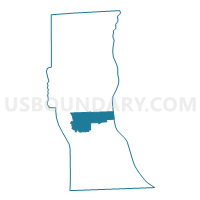
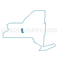
Voting District 060003, Seneca County, New York
About
Outline

Summary
| Unique Area Identifier | 636738 |
| Name | Voting District 060003 |
| County | Seneca County |
| State | New York |
| Area (square miles) | 19.21 |
| Land Area (square miles) | 16.92 |
| Water Area (square miles) | 2.29 |
| % of Land Area | 88.08 |
| % of Water Area | 11.92 |
| Latitude of the Internal Point | 42.73000420 |
| Longtitude of the Internal Point | -76.83083930 |
Maps

Graphs
Select a template below for downloading or customizing gragh for Voting District 060003, Seneca County, New York


Neighbors
Neighoring Voting District (by Name) Neighboring Voting District on the Map
- Voting District 060001, Seneca County, NY
- Voting District 060002, Seneca County, NY
- Voting District 090001, Cayuga County, NY
- Voting District 090001, Seneca County, NY
Top 10 Neighboring County Subdivision (by Population) Neighboring County Subdivision on the Map
- Romulus town, Seneca County, NY (4,316)
- Ledyard town, Cayuga County, NY (1,886)
- Varick town, Seneca County, NY (1,857)
Top 10 Neighboring Place (by Population) Neighboring Place on the Map
Top 10 Neighboring Unified School District (by Population) Neighboring Unified School District on the Map
- South Seneca Central School District, NY (7,153)
- Southern Cayuga Central School District, NY (6,599)
- Romulus Central School District, NY (5,109)